(Continued from Part II)
 After a short bus trip along Main St., we have finally arrived at the Beaches area. The area sort of reminds me of Vancouver's Kitsilano neighbourhood (nice, trendy but remarkably expensive - especially with tiny drizzles falling down during that day). This pic is taken along Queen St. E. looking west from Leuty Ave.
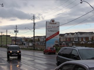 You want to become a part of the neighbourhood and ask questions to your profs easily*? If you don't have at least $1.2 million Canadian, sorry bud, you are out of luck... (that's not to mention that houses are selling like hot cakes despite the high price)
*There are quite a number of them living in the Beaches area.
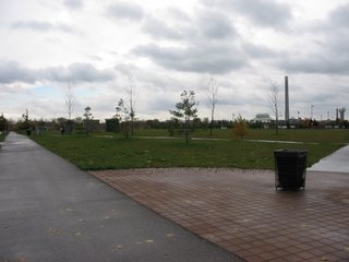 Here is a perfect example of a waste of park space. Without proper support by adjacent areas, that is not to mention about the inaccessibility to the concert stage (right beside the smokestack in the pic), Woodbine Park is as lifeless and unattractive as it can be in one of the nicest neighbourhoods in Toronto. But it was time for the class to leave the Beaches area and catch a streetcar towards downtown.
 Here I deliberately made the CN Tower look shorter than other buildings in the downtown Toronto area, since it always get the attention when one thinks about the city. From right to left: The Spire (an unfinished residential high-rise), Scotia Plaza, Commerce Court West, CN Tower, and Canada Trust Tower.
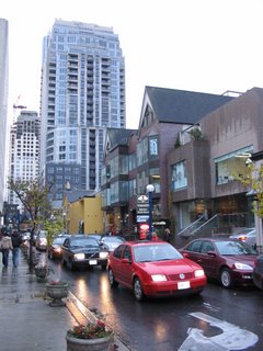
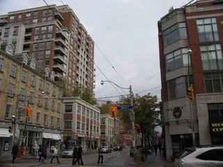 The corner of Jarvis and King St. Even though it is important to intensify and infill areas to support public transit, it is also important to create a pedestrian-friendly realm via the construction of 4-5 storey "podium" buildings. People will find it exciting to walk along areas such as this one. Taller buildings, meanwhile, should have a setback to provide some breathing space to both the street and the people.
When Paul Bedford and the late Jane Jacobs proposed changes to this area (King-Parliament as well as King-Spadina), the staff at the planning department were quickly up in arms. It is not surprising that who got the last laugh after seeing personally the results to these changes.
The class then headed two blocks to the historic St. Lawrence Market to grab something to eat before heading to our next stop.
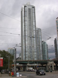 Not wasting valuable time, the class headed straight to the Harbourfront area to see some nice-looking condo developments that have sprung out in the last two decades. Here is a look at some of them on Concord City Place, developed by (you guessed it) the same developers that transformed False Creek North in Vancouver from a derelict district to a pedestrian mecca.
Unfortunately, the City of Toronto did not have much vision in terms of design standards, nor does it have an urban design panel similar to that of Vancouver. The result? Developers are sent back to the drawing board after witnessing the construction of a series of badly-designed buildings along the eastern edges of Spadina Ave.
I'll talk more about the Gardiner Expressway (the elevated highway on the foreground of the picture) a little later.
 This is how condos and apartments should be built: a gradual rise in height from the harbourfront.
 While it is nice to have nice, attractive condos and apartments in the Harbourfront area surrounded by a pleasant network of parks and trails, it is also crucial to have a mix of residents (single or married, and with or without children). This is how true vibrancy can be achieved in an area. And that is the reason why a community centre/elementary school is placed right next to an abandoned wheat elevator on the south side of Lakeshore Blvd W.
 The NE intersection of Lakeshore Blvd W. and Bathurst St. With a streetcar line serving the area, better land use opportunities are available instead of having a parking that does nothing but to discourage the use of one of the most wonderful forms of public transportation Toronto has to offer. From here the class hopped on to a streetcar as it headed west.
 The streetcar route terminates at the fairgrounds of the Canadian National Exhibition (CNE), with the ageless Ricoh Coliseum (home of the Toronto Marlies, the farm team of the Toronto Maple Leafs hockey team - the most hated in Canada outside of Southern Ontario) shown in the pic.
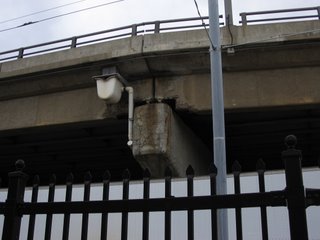 Ahh... Here is a good look at an elevated section of the mighty Gardiner Expressway. Is it worth the millions of dollars annually to repair a behemoth that cities around the world would otherwise have torn down a long time ago? Do we need a repeat of what happened on the Laval freeway overpass before policy-makers on Nathan Phillips Square will take a serious look at this problem? (Pic taken outside of Ricoh Coliseum)
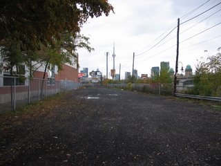 What you are looking now is the future site of the Front Street Extension to link up with the hotly-contested Gardiner Expressway. Despite recommended by Paul Bedford and the Toronto Planning Department to be constructed after the demolition of Gardiner's Downtown section, politicians, in the name of traffic relief, wanted the project to go ahead no matter what. If the latter option goes through, this would spell disaster to the inner areas of Toronto.
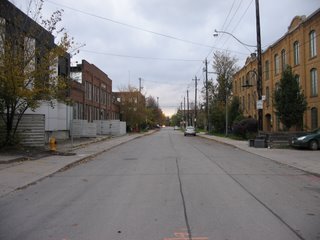 The class then entered into the Liberty District immediately north of CNE. The left-hand side of the street house workshops and incubator companies that are important to the knowledge economy in the twenty-first century. Not surprisingly, the other side consists of residences that are once reserved for industrial uses.
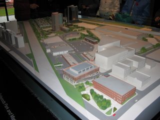 A model of the development around Liberty Village, with two high-rise towers (centre-left of the picture) and low-rise townhouses immediately to the east. And we also have a suburban strip mall (centre) that seriously looks out of place in an urban and historical area such as here. Also a former toy factory (lower right) is in the process of being converted into live-work lofts.
 The lowrise developments in the Liberty District, which bear the resemblance of barracks according to Paul Bedford. To those of you living in one of these units: You have a lack of taste by overpaying developers to move here.
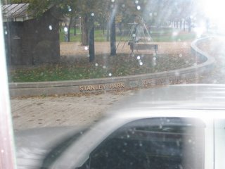 Hey, Toronto has a Stanley Park too! (Pic taken while traveling on the King St. streetcar heading towards Spadina Ave.)
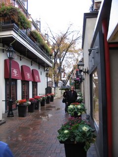
A nice little alley in the trendy Yorkville District in Uptown Toronto. This, like Yaletown in Vancouver, is a good star-gazing spot for those who follow closely on Hollywood and New York.
Yorkville has gone under a dramatic facelift recently as large-sized condos rose out of the ashes of old homes that are not under the official Toronto heritage registry. Prices are starting at a couple of million Canadian dollars.
(Well that is the end of the picture-narration series "A Whirlwind Tour of the Old City of Toronto." Thanks for spending your spare time looking at the meagre collection of photos, and I'll see you in December after submitting my term papers for this semester)

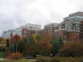
 Does the phrase "towers on podiums" ring a bell to you?
 I was in the area during the first ENVS 6101 Mississauga - Richmond Hill - Markham field trip, and I was amazed at how the ageless Mayor Hazel McCallion had a 180-degree turn (she had the not-so-prestigious title of "Sprawl Queen" by some of her critics) by approving strategies at intensifying the downtown area around Hurontario and Burnhamthorpe (for those of you who are not familiar with the geography of the region).
 Here is my take on Mississauga City Hall from the south side of the building on a sunny but cold and windy Saturday morning. The class even went to the deck section of the clock tower to have a glance at the development around the area. I felt like being in the freezer after standing there for only a few minutes!


