Wednesday, January 31, 2007

A Short Notice

Due to the recent creation of sex-related blogs that have similar names as my clean blog, therefore I have taken some defensive actions to protect my name from being associated with the "dark" side.

I will post pics from my short return trip to Vancouver in December 2006 and the field trip to the Junction area in Toronto between Dundas West, Bloor, and Dupont a little later during my semester break, for I am having a hard time catching up with my work.

Stay Tuned!

Monday, January 08, 2007

Some Pics of Toronto Taken in December

It has been a month before I updated my blog on the 3rd of January, for I was too sleepy after stuffing too much turkey and having too much drinks during the holidays. But I still have some pics to upload when I was strolling in Downtown Toronto and snapping pics along the way. With the exception of a detour to the Distillery District and Moss Park, the route was pretty much north along Yonge St. between Front St. and Bloor St. and west along Bloor from Yonge to somewhere between Dundas St. West and Keele St. I guess I covered more than 10km on foot in a pair of leather shoes.

When you get the angles right, any building can instantly become the "Tower of Power!"


I believe most people have taken a pic at the famous arc inside BCE Place during their visits to Toronto. But this is my first time seeing it decked in Christmas lighting.


It's pretty obvious for planners to place a medium-sized grocery store within a community, as I have mentioned for quite a few times that people do not always have the time to go to the park but they always reserve time for grocery shopping. Having a grocery store livens the streetlife (just take a look at the Dominion store at Bloor near Spadina).

Yes it is proper for the City of Toronto to provide a safe environment for the little children, but not everyone who enjoys David Crombie Park are pedophiles! No wonder the park is deserted during these times.

A form of resistance to the media status quo can be seen in this picture, as some independent outlets just couldn't face the onslaught from global media giants or they are purchased outright by the same group of people with money in their hands.


If I came to the Distillery District a little earlier, I would have taken the same picture under better lighting.


This is my best shot of the entrance to the Distillery District. I shook on the rest of them as soon as I turned off flash.


I didn't know this is a high school for the artistically gifted until my friend Lauralyn told me about the place and its strict rules during an ENVS 5121 field trip.


We have some pretty unique architecture right here on a quiet street in Corktown, a former haven for Irish immigrants in the early days. Now gentrification is almost complete.

A pretty cool graffiti along King St. East, though I do not know what it says on the wall.


Pic taken in front of an architectural firm along King St. East within the boundaries of Corktown.


This pic could be featured on a Toronto tourist postcard. Before these billboards were placed a few years ago, Toronto is referred to as the "Small Apple," which is obviously symbolizing the relationship with New York. Following the footsteps of Times Square, Piccadilly Circus in London, Tokyo, and along Nathan and Hennessey Roads in Hong Kong, cities around the world are constructing billboard plazas to reflect the glamour and vibrancy a city offers (the ones in Tokyo are in Japanese rather than in English).

The facade of this building on the northeastern corner of Yonge and Dundas St. should be covered with billboard advertisements as authorities in Nathan Phillips Square wanted the best of Times Square (the ads) and Piccadilly Circus (like the space with the Eros fountain, a large public square that is... ahem ... not highly public).

A night scene along Bloor between Spadina and Bathurst, also known as the Annex, with lots of restaurants and pubs catering to the hungry students at University of Toronto nearby.

A Christmastime symbol of entry to Koreatown on Bloor between Christie and Bathurst.


"I saw mommy kissing Santa Claus... in a bridal outfit!" - Pic taken in front of bridal shop near Bloor and Ossington (? - I couldn't remember)


After a lengthy walk along Bloor St. from Yonge St. to somewhere between Dundas St. West and Keele St. (a little west of Bloor GO Station), my legs forced me to take the subway back to St. George Station, where a gathering between planning students of Toronto, York, and Ryerson took place nearby.

Thursday, January 04, 2007

New Buses for TransLink

During my Christmas break back in Vancouver (Port Coquitlam to be exact), I have noticed the presence of new buses decked in the colours of grey, black, blue, and yellow, in contrast to the existing ones which are mostly white in colour. Also citizens in Downtown Vancouver got a sneak peek at the next-gen trolley buses servicing mostly on routes 5 (Robson) and 6 (Davie), which are highly popular with tourists.

There were a few things I have noticed when I was in these new buses:

1. Most of them run on compressed natural gas, though some of them still run on diesel (which drew TransLink -- the transportation authority responsible for all municipalities in the Greater Vancouver Regional District-- a lot of criticism).

2. Since only the Port Coquitlam bus depot has natural gas pumps and related maintenance facilities present (someone please correct me if this is not the case), most of the new buses therefore ran along major routes in the Northeast Sector, New Westminster, and Maple Ridge/Pitt Meadows (though the small fleet of new diesel buses are serving other areas such as Burnaby and Richmond).

3. The seats are not as comfortable as the ones on previous generation buses, though they offer better back support. The steel based seats however do provide cleaners a faster solution in removing the large amounts of graffiti, which I admit is a huge problem (at least compared to buses operated by the Toronto Transit Commission).


4. The new trolley buses (pictured above) seemed to offer more standing space compared to older-generation trolleys. Good to see TransLink in finally addressing the needs of the disabled by introducing low-floor replacements to the current ones that are over 20 years old. Also the trolley poles on the new buses are apparently less likely to fall off. Scenes like the pic to the left are not funny to bus operators, passengers, pedestrians, and motorists (as both buses blocked the intersection of Howe and Robson during one afternoon rush hour).

Wednesday, January 03, 2007

Random Urban-Related Thoughts of the Day

Someone might have said what I said earlier, but oh well...

On architecture: "People should not love a building because of its aesthestics. People should love a building because of the wonderful experiences and the limitless possibilities of being inside it."

Saturday, December 02, 2006

Mississauga is Now an Avid Follower of the Vancouver Model

Does the phrase "towers on podiums" ring a bell to you?

The newest version of the "City of Glass" (termed famously by writer and Vancouverite Douglas Coupland) is emerging in this Toronto suburb as Vancouver-based developers are assisting staff at Mississauga City Hall in creating a mini-Vancouver out of the flat landscape surrounding Square One Mall, dominated by grand pedestrian-friendly boulevards. Even planners are dreaming of a central park once the mall becomes obsolete as a result of the changes in consumer taste in shopping along the streets!

I was in the area during the first ENVS 6101 Mississauga - Richmond Hill - Markham field trip, and I was amazed at how the ageless Mayor Hazel McCallion had a 180-degree turn (she had the not-so-prestigious title of "Sprawl Queen" by some of her critics) by approving strategies at intensifying the downtown area around Hurontario and Burnhamthorpe (for those of you who are not familiar with the geography of the region).

Downtown Mississauga should receive primary consideration (after the ill-planned Spadina extension to Vaughan Corporate Centre via York University - since VCC will not have the required density to support it) should funding for a subway expansion west of Kipling Station be available, since it has the potential to surpass the minimum population density to support a subway line.

Here is the much-talked-about Marilyn Monroe building (on the right-hand side of the picture below) and her male counterpart. Again notice the townhouses at the bottom serving as podiums to foster
Here is my take on Mississauga City Hall from the south side of the building on a sunny but cold and windy Saturday morning. The class even went to the deck section of the clock tower to have a glance at the development around the area. I felt like being in the freezer after standing there for only a few minutes!

Wednesday, November 15, 2006

Double Irony

There was an accident on the intersection of Victoria Park and Finch Avenues, and the Toronto Star decides to put this pic in front of the GTA section on today's newspaper.

The first irony, as the pic suggests, is having a police vehicle and a beer truck colliding with each other.

The second irony is that most people will link it to drunk driving as soon as they see the sheer amounts of booze that was on the truck. If you look at the title, it was actually the cruiser ramming into the truck instead of the other way around.


Anyway, I gotta hurry to the library again to work on my term papers. See ya later!

Monday, November 13, 2006

A Whirlwind Tour of the Old City of Toronto, Part III

(Continued from Part II)

After a short bus trip along Main St., we have finally arrived at the Beaches area. The area sort of reminds me of Vancouver's Kitsilano neighbourhood (nice, trendy but remarkably expensive - especially with tiny drizzles falling down during that day). This pic is taken along Queen St. E. looking west from Leuty Ave.
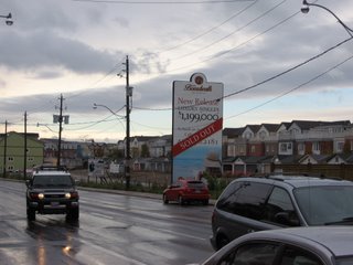
You want to become a part of the neighbourhood and ask questions to your profs easily*? If you don't have at least $1.2 million Canadian, sorry bud, you are out of luck... (that's not to mention that houses are selling like hot cakes despite the high price)

*There are quite a number of them living in the Beaches area.
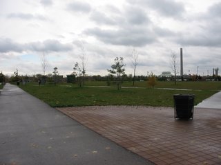
Here is a perfect example of a waste of park space. Without proper support by adjacent areas, that is not to mention about the inaccessibility to the concert stage (right beside the smokestack in the pic), Woodbine Park is as lifeless and unattractive as it can be in one of the nicest neighbourhoods in Toronto. But it was time for the class to leave the Beaches area and catch a streetcar towards downtown.

Here I deliberately made the CN Tower look shorter than other buildings in the downtown Toronto area, since it always get the attention when one thinks about the city. From right to left: The Spire (an unfinished residential high-rise), Scotia Plaza, Commerce Court West, CN Tower, and Canada Trust Tower.
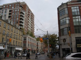
The corner of Jarvis and King St. Even though it is important to intensify and infill areas to support public transit, it is also important to create a pedestrian-friendly realm via the construction of 4-5 storey "podium" buildings. People will find it exciting to walk along areas such as this one. Taller buildings, meanwhile, should have a setback to provide some breathing space to both the street and the people.

When Paul Bedford and the late Jane Jacobs proposed changes to this area (King-Parliament as well as King-Spadina), the staff at the planning department were quickly up in arms. It is not surprising that who got the last laugh after seeing personally the results to these changes.

The class then headed two blocks to the historic St. Lawrence Market to grab something to eat before heading to our next stop.
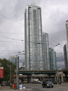
Not wasting valuable time, the class headed straight to the Harbourfront area to see some nice-looking condo developments that have sprung out in the last two decades. Here is a look at some of them on Concord City Place, developed by (you guessed it) the same developers that transformed False Creek North in Vancouver from a derelict district to a pedestrian mecca.

Unfortunately, the City of Toronto did not have much vision in terms of design standards, nor does it have an urban design panel similar to that of Vancouver. The result? Developers are sent back to the drawing board after witnessing the construction of a series of badly-designed buildings along the eastern edges of Spadina Ave.

I'll talk more about the Gardiner Expressway (the elevated highway on the foreground of the picture) a little later.
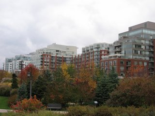
This is how condos and apartments should be built: a gradual rise in height from the harbourfront.


While it is nice to have nice, attractive condos and apartments in the Harbourfront area surrounded by a pleasant network of parks and trails, it is also crucial to have a mix of residents (single or married, and with or without children). This is how true vibrancy can be achieved in an area. And that is the reason why a community centre/elementary school is placed right next to an abandoned wheat elevator on the south side of Lakeshore Blvd W.

The NE intersection of Lakeshore Blvd W. and Bathurst St. With a streetcar line serving the area, better land use opportunities are available instead of having a parking that does nothing but to discourage the use of one of the most wonderful forms of public transportation Toronto has to offer. From here the class hopped on to a streetcar as it headed west.

The streetcar route terminates at the fairgrounds of the Canadian National Exhibition (CNE), with the ageless Ricoh Coliseum (home of the Toronto Marlies, the farm team of the Toronto Maple Leafs hockey team - the most hated in Canada outside of Southern Ontario) shown in the pic.
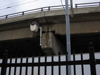


Ahh... Here is a good look at an elevated section of the mighty Gardiner Expressway. Is it worth the millions of dollars annually to repair a behemoth that cities around the world would otherwise have torn down a long time ago? Do we need a repeat of what happened on the Laval freeway overpass before policy-makers on Nathan Phillips Square will take a serious look at this problem? (Pic taken outside of Ricoh Coliseum)
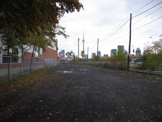
What you are looking now is the future site of the Front Street Extension to link up with the hotly-contested Gardiner Expressway. Despite recommended by Paul Bedford and the Toronto Planning Department to be constructed after the demolition of Gardiner's Downtown section, politicians, in the name of traffic relief, wanted the project to go ahead no matter what. If the latter option goes through, this would spell disaster to the inner areas of Toronto.
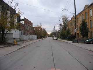
The class then entered into the Liberty District immediately north of CNE. The left-hand side of the street house workshops and incubator companies that are important to the knowledge economy in the twenty-first century. Not surprisingly, the other side consists of residences that are once reserved for industrial uses.
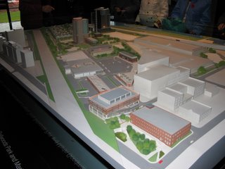
A model of the development around Liberty Village, with two high-rise towers (centre-left of the picture) and low-rise townhouses immediately to the east. And we also have a suburban strip mall (centre) that seriously looks out of place in an urban and historical area such as here. Also a former toy factory (lower right) is in the process of being converted into live-work lofts.

The lowrise developments in the Liberty District, which bear the resemblance of barracks according to Paul Bedford. To those of you living in one of these units: You have a lack of taste by overpaying developers to move here.
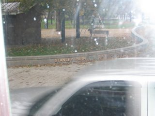
Hey, Toronto has a Stanley Park too! (Pic taken while traveling on the King St. streetcar heading towards Spadina Ave.)
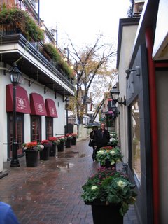


A nice little alley in the trendy Yorkville District in Uptown Toronto. This, like Yaletown in Vancouver, is a good star-gazing spot for those who follow closely on Hollywood and New York.
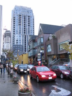


Yorkville has gone under a dramatic facelift recently as large-sized condos rose out of the ashes of old homes that are not under the official Toronto heritage registry. Prices are starting at a couple of million Canadian dollars.

(Well that is the end of the picture-narration series "A Whirlwind Tour of the Old City of Toronto." Thanks for spending your spare time looking at the meagre collection of photos, and I'll see you in December after submitting my term papers for this semester)

Saturday, November 11, 2006

A Whirlwind Tour of the Old City of Toronto, Part II

(Continued from Part I)

A nice blend of the new and old, with the exception of the brownish colouring that is typical of buildings around Toronto.

Pic taken south of the Yonge-St. Clair intersection.


Apparently developers try to add a little Parisien flavour onto the streets of Toronto.

Taken a few blocks north of the Summerhill subway station.


Here is an attempt to provide an artistic look to residents along Yonge St. The water on the lens has blurred the picture a littlebit.


This LCBO* joint south of Summerhill subway station was once a passenger train station (North Toronto) before Canadian Pacific pulled out of the business a long time ago. Here, you can find an expanse selection of all sorts of alcohol from around the world. Certainly I will visit this place during the semester break when I explore the sights and sounds Toronto has to offer.

Unfortunately, some of the class were refrained from taking pictures of the architecture inside for commercial reasons. That's too bad.

*LCBO (Liquor Control Board of Ontario) is the chain of liquor stores run by the Ontario Provincial Government. Sadly, it can only sell beer in half-dozens or less. On the other hand, the Beer Store, a private chain of outlets that only sells beer as its name suggests, is able to offer alcohol-hungry customers the choice of purchasing booze in large quantities.

Thankfully, permits for suburban-style commercial uses such as the Starbucks pictured here along Yonge St. (which is a total waste of space and can be intensified) is no longer allowed.

What you are seeing right here on Yonge St. north of Rosedale subway station is not a complex of converted residential buildings. This is actually one single house bought by the owner of an architectural firm. My memories are fading in terms of how did this happen, so let's move on...

A weird-looking mixed-use building on Yonge St. north of Bloor St. that was built in the 1970s., with office space at the bottom and retirement homes on top. After a lunch stop at one of the many Starbucks/Tim Hortons in Toronto, it was time to say so long to Yonge after spending a couple of hours walking and riding the subway along the longest street in the world.


After a lengthy subway ride from Yonge-Bloor station, we see some better maintained public housing units on the SE corner of Danforth Ave. and Main Street. According to Mike who lives around the area, this space can become packed with people during summer days.

Well... What else can I say about this tasteless ad?
(Pic taken at the same intersection - just south of the Main Street subway station)

(To be continued)